The Earth's crust has the deepest faults under the waters of the World Ocean, which are usually called sea depressions or gutters. These places are not thoroughly studied by science, because of their incredible depth.
The top 10 includes the deepest depressions of the World Ocean , known to date.
10
Aleutian chute

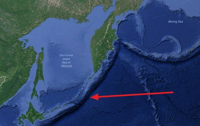
The Aleutian chute opens the ten deepest depressions of the World Ocean. Passes along the southern coast of Alaska and stretches to the coast of the peninsula of Kamchatka. The length is 3400 km, the maximum depth is 7679 m. It is the boundary between lithospheric plates. The North American plate, creeping on the Pacific plate, forms along the trough an island arc of the Aleutian Islands. In the west in the Commander area, the depression passes into the Kuril-Kamchatka Trench, which has a south-western direction.
9
Javanese or sonde depression

The Javanese or Sind hollow is one of the deepest in the eastern Indian Ocean. It extends for 4-5 thousand km along the southern part of the Sunda island arc. The gully starts at the foot of the continental slope of Myanmar in the form of a shallow trough with a bottom width of up to 50 km. Then, towards the island of Java, gradually deepens and its bottom narrows to 10 km. The maximum depth reaches 7730 meters, which makes it the deepest depression in the Indian Ocean. The bottom of the trench to the southeast of Java is a series of basins separated by rapids. Slopes are steep, asymmetrical, island above and steeper than oceanic and more dissected by canyons and complicated by steps and ledges. In the northern and central parts of the bottom, up to 35 km wide, is lined with a layer of terrigenous sediments with a large admixture of volcanic material, whose thickness in the north reaches 3 km. In the Sunda Trench, the Australian plate dives under the Sound plate, forming a subduction zone. It is seismically active and is part of the Pacific Fire Ring.
8
Puerto Rico

Puerto Rico is a deep ocean basin located on the border of the Caribbean Sea and the Atlantic Ocean. The formation of the trench is associated with a complex transition between the subduction zone from the south along the island arch of the Lesser Antilles and the zone of transform fault( plate boundary) extending eastward between Cuba and Haiti through the Cayman trench to the coast of Central America. The conducted studies confirmed the possibility of the appearance of significant tsunamis as a result of earthquakes in this region. The island of Puerto Rico is located directly from the south of the basin. The length of the gutter is 1754 km, the width is about 97 km, the greatest depth is 8380 m, which is the maximum depth of the Atlantic Ocean. Measurements made in 1955 from the American vessel "Vima", showed the depth of Puerto Rico 8385 meters.
7
Izu-Boninskaya depression

Izu-Boninskaya depression or Izu-Ogasavar trough is one of the deepest Pacific Ocean located along the eastern foot of the Nampo Islands ridge stretching from Honshu Island to the Bonin Islands. In the north it joins the Japanese trench, in the south it is separated from the volcano gutter by a high narrow crest. The length of the gutter is 1030 km. Narrow, sometimes flat bottom of the gutter is divided by thresholds into several closed depressions with depths of 7000-9000 m. The maximum depth - 9810 meters was established in 1955 by the Soviet expedition on the Vityaz vessel.
6
Kermadec

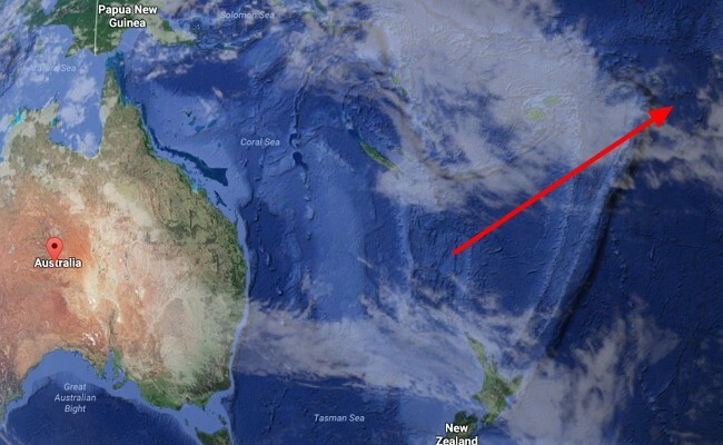
Kermadec is one of the deepest depressions in the north connected to the Tonga chute. Located at the eastern foot of the Kermadec islands almost in the meridional direction. The length is about 1200 km. Kermadec was opened in 1889 by an expedition of the British vessel Penguin. The maximum depth of 10,047 meters was measured in 1958 during the voyage of the Soviet research vessel Vityaz. The hollow is named after Yuon de Kermadec
5
Japanese chute

The Japanese chute is a deep depression in the west of the Pacific Ocean east of Honshu, south of Hokkaido and north of the Bonin Islands. The length of the gutter exceeds 1000 km. The transverse profile of the chute is V-shaped. The maximum measured depth is 10,504 m. The depression is the southern extension of the Kurile-Kamchatka Trench. Three researchers on the device Shinkai 6500 August 11, 1989 reached a depth of 6526 m. In October 2008, the Japanese-British expedition managed to capture at a depth of 7,700 m sea slugs - the deepest fish. The bottom and walls of the crack often become epicenters of earthquakes.
4
Kuril-Kamchatka Trench

The Kuril-Kamchatka Trench occupies the fourth line in the top of the deepest depressions of the World Ocean. It is located at the eastern underwater slopes of the Kuril Islands and the southern part of the Kamchatka Peninsula. The length is 2170 km, the average width is 59 km. The maximum depth is 10542 m. The boundaries of the basin roughly coincide with the 6000 m isobath. On the slopes there are numerous ledges, terraces, and valleys descending to the maximum depth. It was investigated mainly in the 1950s by Soviet expeditions on the Vityaz vessel.
3
Philippine trench

The Philippine trench opens the three deepest depressions of the World Ocean. Located east of the Philippine Islands. Its length is 1320 km, from the northern part of the island of Luzon to the Molluk Islands. The deepest point is 10540 m. The Philippine gutter is the result of a collision of earth layers. Oceanic, with a 5-kilometer width, but with a specific specific gravity( basalt), the Philippine Sea Plate moves at a speed of 16 cm per year under the 60-kilometer, with a smaller specific gravity( granite), the Eurasian Plate, and melts at the expense of the Earth's mantledepth from 50 to 100 km. This geophysical process is called subduction. In this area is the Philippine hollow.
2
Tonga

Tonga is the second line in the list of the deepest depressions of the World Ocean. Its total length is 860 km. It extends along the foot of the eastern slope of the same underwater ridge from the islands of Samoa and the Kermadec gutter. The depth along the isobath is about 6,000 m - about 80 km. The maximum depth is 10 882 m - the deepest depth of the World Ocean in the Southern Hemisphere.

The Mariana Trench is the deepest hollow of the World Ocean. The deepest point is the "Challenger's Abyss", which is 10,994 meters below sea level.recent studies conducted by the American Oceanographic Expedition from the University of New Hampshire( USA), found on the surface of the bottom of the Mariana Trench the most real mountains. Studies were conducted from August to October 2010, when a bottom area of 400,000 square kilometers was studied in detail with the help of a multi-beam echo sounder. As a result, at least 4 oceanic mountain ranges 2.5 km in height intersecting the surface of the Mariana Trench at the point of contact between the Pacific and Philippine lithospheric plates were discovered.


